Saturday, September 7, 2019

President Trump was correct as he reported on the original forecast models concerning Hurricane Dorian

*****PRESIDENT TRUMP WAS CORRECT******

EVEN CNN REPORTED ON ALABAMA


So President Trump was right and it looks like the mainstream media just wants to pounce on him for accurately reading and mentioning the original forecast tracks of Hurricane Dorian.  Even the National Weather Service is ganging up on President Trump over this:

I went back and watched this all myself and the SHARPIE PEN OUTLINE is simply showing where the WIND PROBABILITIES where on a COLOR CODED CHART that actually shows an extension into the state of Alabama and surrounding locations.  

The mainstream media is nuts!  They are the ones actually twisting this making many of us (including myself) think that President Trump actually was wrong when he was right about the original storm model projections hitting Alabama.  Well originally the forecast winds were extended there even though that other forecast cone was not.  You have to look at all the NHC products to actually see this. There is more than one product and chart. WATCH MY VIDEO REPORT BELOW where I explain this.

MAINSTREAM MEDIA YOU ARE WRONG.  AND SHAME ON YOU FOR CONVINCING MANY OF US YOU WERE RIGHT.  TRUMP'S RIGHT!  YOU ARE FAKERS WITH FAKE NEWS.  ALSO YOU HYPE THIS HURRICANE SO MUCH THAT YOU CAUSE MUCH MONEY WASTE, FRAUD, and ABUSE OVER THIS ENTIRE STORM.

TRUMP WAS RIGHT!  I apologize Mr. President if I said you were wrong.  I have review this further now and see clearly now what happened:


President Trump insists Hurricane Dorian hit Alabama?

******Meteorologist Donald Trump******


*****...and FAKE WEATHER:******

Are these President Trump's actual TWEETS?

Or are these FAKE TWEETS?

I guess he really thinks Hurricane Dorian hit Alabama?


Monday, September 2, 2019

HURRICANE DORIAN COVERAGE

*****DOWNGRADED: CATEGORY 4*****

*****HISTORIC HURRICANE DORIAN*****


WAS 185 to 225 MPH WINDS 

Now down to 145 MPH

Is this more FAKE WEATHER NEWS?

Each time there's a HURRICANE it is usually winds being reported aloft with the dropsonde and onboard computer equipment with hurricane hunter aircraft.  It is not happening at the surface.  Until we can see an actually anemometer at the surface that registers 185 to 225MPH winds I don't believe these are credible surface wind reports.  Even the downgrade to 145 MPH are winds that are slightly elevated off the surface.  

AccuWeather is reporting on this but how accurate is AccuWeather?  I haven't seen an actual surface report and cannot find a METAR on this at all at the moment:


..developing...

Monday, July 29, 2019

THE UNSEASONABLE WEATHER PATTERNS CONTINUE FOR 2019 AND HERE COMES AND EARLY FALL

*****COLDER THAN NORMAL TEMPERATURES SETTING IN******

*****THE CALENDAR SAYS JULY 29TH*****

******IT'S MORE LIKE LATE AUGUST*****

Prepare for another round of BELOW NORMAL TEMPERATURES for a good portion of the CONUS.  This could even get worse as those back door fronts and Continental Polar air masses sag further south from Canada:


....developing...

Saturday, June 22, 2019

What is a meteorologist? Do they study meteorites, asteroids, and astronomy?

I was told I'm a meteorologist:

Recently I was told by a meteorologist that I am a meteorologist.  Or do I have to be accredited by the American Meteorological Society AMS?  I'm still researching this because of my past studies and my studies and related training in the air traffic control profession and also as a pilot.  

In the meantime I'll just say I'm a meteorologist in part and in the meantime I'll call myself an atmosphereologist. How's that?  Is that OK? In today's culture you can be anything you want to be in the LGBTQQIAAP environment, so by all means if I feel like a meteorologist today I'm going to be one:


....develolping....

Paul Joseph: The best meteorologist in the history of America from Milwaukee, Wisconsin

Paul Joseph

Chief Meteorologist

WTMJ/WKTI Milwaukee, Wisconsin


This guy was simply the best and even if you didn't understand weather but paid attention to his reports daily along with his associate Jim Ott, you would learn very much about weather.  Today no one can really learn anything by watching television because most people are just news and weather puppets.  This guy had brains and used them.  Those days are long gone now as computers and models have take over the use of the human brain:

Saturday, June 8, 2019

GULF MOISTURE CUT OFF: WHAT IS GOING ON?

*****WHAT IS WRONG WITH THE WEATHER?******

Is this GLOBAL WARMING?

Is this CLIMATE CHANGE?

Or is it WEATHER MODIFICATION?


Friday, June 7, 2019

LIVE: THE WEATHER UNIT: SEVER WEATHER SYNOPSIS & DISCUSSION

Remember to visit The Weather UNIT You Tube Channel and support this endeavor with your love...

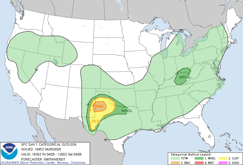
SWODY1 OVERVIEW 1126 AM CDT FRI JUN 07 2019


 SPC AC 071626

   Day 1 Convective Outlook  
   NWS Storm Prediction Center Norman OK
   1126 AM CDT Fri Jun 07 2019

   Valid 071630Z - 081200Z

   ...THERE IS AN ENHANCED RISK OF SEVERE THUNDERSTORMS THIS
   AFTERNOON/EVENING ACROSS PARTS OF THE NORTHERN HIGH PLAINS...

   ...THERE IS A SLIGHT RISK OF SEVERE THUNDERSTORMS THIS AFTERNOON FOR
   PARTS OF SOUTHERN AL AND WEST CENTRAL GA...

   ...SUMMARY...
   Thunderstorms should produce severe hail and winds over a portion of
   the northern Plains this afternoon into evening, while storms this
   afternoon could produce a few damaging gusts across parts of Alabama
   and Georgia.

   ...Northern High Plains this afternoon into tonight...
   A pronounced mid-upper trough over the interior Pacific Northwest
   and northern Rockies will move slowly eastward toward the northern
   High Plains through early Saturday.  An associated surface cold
   front will likewise move slowly east-southeastward across WY,
   eastern MT, and western ND, though progress of the front will be
   slowed some today by cyclogenesis in the lee of the Wind River Range
   in WY.  Low-level moisture is modest across the northern High Plains
   this morning, with some increase possible across the Dakotas through
   weak advection and local evapotranspiration.  However, the primary
   driver of buoyancy this afternoon will be surface heating/deep
   mixing near the lee cyclone/trough and along the cold front closer
   to the Big Horn Mountains.

   High-based thunderstorm development is expected by early-mid
   afternoon across northwest and north central WY as ascent downstream
   from an embedded speed max over the northern Great Basin interacts
   with the deepening boundary layer and at least weak surface-based
   buoyancy.  Deep-layer vertical shear will favor supercells
   initially, with the potential to produce large hail and damaging
   winds.  Eventual upscale growth into organized/bowing clusters is
   probable as convection spreads northeastward this evening along the
   front into the Dakotas through early tonight.  Weakening buoyancy
   and increasing convective inhibition after about 05z should result
   in a diminishing threat of severe storms. 

   ...Southeast states this afternoon/evening...
   A midlevel low and weak surface reflection over AR as of late
   morning will only drift eastward through tonight.  Surface heating
   within a very moist low-level air mass is contributing to moderate
   buoyancy in a corridor from southeast LA into AL/GA, in advance of
   ongoing/loosely organized storm clusters.  Continued destabilization
   in conjunction with modest (roughly 30 kt) low-midlevel
   southwesterly flow will support a threat for expansion of the
   ongoing convection as a few multicell clusters capable of producing
   a few marginally severe outflow gusts with resultant wind damage.  

   Along the northeast edge of the richer moisture and more unstable
   warm sector, there will be a zone of somewhat enhanced low-level
   shear/hodograph curvature across SC this afternoon.  Here, weak
   supercell structures will be possible with an attendant threat for a
   brief tornado.  However, the extent of the threat will be limited by
   rather modest low-level flow/SRH (effective SRH generally 150 m2/s2
   or less) and deep-layer shear (effective bulk shear of 30 kt or
   less), in an environment with poor midlevel lapse rates.

   ..Thompson/Squitieri.. 06/07/2019

   CLICK TO GET WUUS01 PTSDY1 PRODUCT

   NOTE: THE NEXT DAY 1 OUTLOOK IS SCHEDULED BY 2000Z
   CURRENT UTC TIME: 1853Z (1:53PM), RELOAD THIS PAGE TO UPDATE THE TIME

Friday, May 31, 2019

MONITORING SEVERE WEATHER POSSIBILITIES FOR WISCONSIN TODAY

ARX AREA FORECAST DISCUSSION 530 AM CDT FRI MAY 21 2019

 
362 
FXUS63 KARX 311030 
AFDARX 
 
AREA FORECAST DISCUSSION 
NATIONAL WEATHER SERVICE LA CROSSE WI 
530 AM CDT FRI MAY 31 2019 
 
SHORT TERM 
(TODAY AND TONIGHT) 
ISSUED AT 341 AM CDT FRI MAY 31 2019 
 
A SLOW-MOVING UPPER LOW CONTINUES TO CREEP EASTWARD ACROSS CENTRAL 
ILLINOIS EARLY THIS MORNING AND WILL SOON DEPART INTO THE OHIO 
VALLEY AS A FLATTENING UPSTREAM RIDGE BUILDS INTO THE MID- 
MISSISSIPPI VALLEY. WARM AIR ADVECTION ALOFT IS ONGOING OUT AHEAD OF 
THIS RIDGING WITH H8 TEMPS OVER LA CROSSE CLIMBING FROM AROUND 13C 
THURSDAY EVENING TO 16C BY DAYBREAK. AT THE SURFACE, LOW PRESSURE 
SITS OVER NORTH-CENTRAL MINNESOTA WITH A WEAK BOUNDARY EXTENDING 
SOUTHEASTWARD THROUGH CENTRAL WISCONSIN.   
 
GOING TO BE A TOASTY END TO MAY ACROSS THE AREA TODAY. DESPITE THE 
UPPER RIDGING BEING DAMPENED AS IT BUILDS OVERHEAD, 850MB TEMPS WILL 
CLIMB FURTHER TO AROUND 18C THIS AFTERNOON WITH 925MB TEMPS FLIRTING 
WITH 25C (2-3 STANDARD DEVIATIONS ABOVE THE MEAN). DEEP 
UNIDIRECTIONAL WESTERLY FLOW PICKS UP THIS AFTERNOON (SOME GUSTS OF 
25-30 MPH POSSIBLE) AS THE LOW OVER NORTHERN MN ADVANCES INTO 
NORTHERN WI. THIS WILL PROVIDE DEEP BOUNDARY LAYER MIXING TO EASILY 
TAP INTO THAT SIGNIFICANT WARMTH, WITH FORECAST SOUNDINGS SUGGESTING 
MIXING ALL THE WAY UP TO ALMOST 600 MB. LIKELY VERY LITTLE CLOUD 
COVER THROUGH AT LEAST MID AFTERNOON, BUT DO ANTICIPATE SOME 
LINGERING SMOKE ALOFT AS PER LATEST HRRR AND RAP VERTICALLY 
INTEGRATED SMOKE PRODUCTS...PROBABLY NOT AS THICK AS IT WAS ON 
THURSDAY. ALL THIS POINTS TO A FAVORABLE SETUP FOR EFFICIENT DAYTIME 
HEATING, BUT RAW GUIDANCE IS JUST NOT CAPTURING THE MAGNITUDE VERY 
WELL. HAVE THEREFORE LEANED TOWARDS BIAS-CORRECTED GUIDANCE WHICH 
HAS MANY LOCALES FLIRTING WITH 90 DEGREES THIS AFTERNOON. 
 
SHOWERS AND STORMS WILL DEVELOP LATER THIS AFTERNOON IN THIS 
UNSTABLE AIRMASS, WITH THE POTENTIAL STILL THERE FOR SOME STRONG TO 
SEVERE STORMS IN OUR NORTHERN ZONES. MOISTURE WILL BE ADEQUATE WITH 
THE REGION BLANKETED BY PWATS NEAR 1.2 INCHES AND SURFACE DEWPOINTS 
HOVERING AROUND 60 DEGREES, THOUGH FORECAST SOUNDINGS SHOW A RATHER 
DRY INVERTED-V PROFILE IN THE LOW LEVELS. RAP PAINTS AROUND 1000- 
2500 J/KG OF MLCAPE ACROSS THE FORECAST AREA THIS AFTERNOON. IN 
TERMS OF FORCING, A CORRIDOR OF FRONTOGENESIS WILL SAG SOUTHWARD 
WITH TIME INTO TAYLOR AND CLARK COUNTIES, PROVIDING THE MAIN IMPETUS 
FOR STORM DEVELOPMENT THIS AFTERNOON. BEST 0-6KM SHEAR OF 30-40 
KNOTS WILL GENERALLY BE CONFINED TO THE IMMEDIATE VICINITY OF THE 
FRONT AS IT DROPS SOUTH, SO OUR FAR NORTH WILL SEE THE GREATEST 
CHANCE FOR ANY STRONG TO SEVERE STORMS. IN TERMS OF TIMING, CAPPING 
LOOKS TO ERODE IN THE 2-4PM WINDOW, BUT STORM DEVELOPMENT LOOKS TO 
BE DELAYED A LITTLE LONGER UNTIL THE FRONT DROPS IN FROM THE NORTH. 
CAMS SHOW A BROKEN LINE OF STORMS DEVELOPING ALONG THE FRONT AS IT 
ENTERS TAYLOR AND CLARK COUNTIES ROUGHLY BETWEEN 5-7PM, WITH STORM 
INTENSITY DIMINISHING TOWARDS SUNSET AS THE LINE PROGRESSES 
SOUTHEAST. LATEST HREF DOES SHOW SOME WEAK UPDRAFT HELICITY IN THE 
75-150 M2/S2 RANGE ACROSS THE CHIMNEY COUNTIES, SO THAT WILL BE THE 
AREA TO WATCH FOR MORE ORGANIZED STORMS AND SEVERE POTENTIAL. GIVEN 
THE INVERTED-V SOUNDING PROFILE, GUSTY WINDS WOULD BE THE MAIN 
THREAT. LOWER THREAT FOR LARGE HAIL, AS LOW LEVELS LOOK TOO DRY AND 
TOO WARM. ONE OTHER AREA TO NOTE LATE THIS AFTERNOON INTO EARLY 
EVENING WILL BE FAR SOUTHWEST WI INTO NORTHEAST IA WHERE A RICHER 
POOL OF INSTABILITY WILL DEVELOP, PERHAPS SUPPORTING SOME PULSE 
POP-UP STORMS DOWN THAT WAY. BUT THOSE ARE NOT LIKELY TO POSE A 
SEVERE THREAT GIVEN THE LACK OF SHEAR. 
 
ACTIVITY WILL WEAKEN AND BECOME LESS ORGANIZED AS IT PROGRESSES 
SOUTHWARD OVERNIGHT. LOWS TONIGHT WILL RANGE FROM LOW 50S NORTH 
BEHIND THE FRONT TO LOW 60S IN THE FAR SOUTH. 
 
LONG TERM 
(SATURDAY THROUGH THURSDAY) 
ISSUED AT 341 AM CDT FRI MAY 31 2019 
 
THE SURFACE LOW AND COLD FRONT WILL HAVE PROGRESSED SOUTH OF I-90 BY 
SATURDAY MORNING. AN INCOMING SHORTWAVE WILL PROVIDE SOME ADDITIONAL 
SUPPORT FOR MORE SHOWERS AND STORMS THROUGH THE MORNING, WITH THE 
BEST FORCING THEN MOVING OFF TO OUR EAST IN THE AFTERNOON AS HIGH 
PRESSURE ENCROACHES FROM THE WEST. DO NOT ANTICIPATE ANY SEVERE 
STORMS ON SATURDAY WITH VERY LITTLE SHEAR IN PLACE. A COMPARATIVELY 
MUCH COOLER DAY IN STORE WITH HIGHS NEAR 70 NORTH TO MID 70S SOUTH. 
 
LOOKS LIKE A STRETCH OF RATHER QUIET, DRY WEATHER WITH SEASONABLE 
(IF NOT SLIGHTLY COOL) TEMPERATURES AS THE SURFACE HIGH SLOWLY 
BUILDS OVERHEAD THROUGH THE REMAINDER OF THE WEEKEND INTO EARLY NEXT 
WEEK. NEXT BEST SHOT FOR RAIN WILL COME HEADING INTO TUESDAY AS 
STRONGER MOISTURE TRANSPORT DEVELOPS OVER THE PLAINS AND EDGES INTO 
THE MISSISSIPPI VALLEY. PLENTY OF MODEL TIMING VARIANCE BEING THIS 
FAR OUT, BUT IT LOOKS LIKE TUESDAY AFTERNOON AND EVENING WOULD BE 
THE MOST FAVORED TIMEFRAME FOR ACTIVITY ACROSS OUR AREA. 
 
SURFACE HIGH PRESSURE IS PROGGED TO SETTLE IN BEHIND THAT SYSTEM FOR 
WEDNESDAY AND THURSDAY WITH A RETURN TO QUIETER WEATHER. 
TEMPERATURES REMAIN SEASONABLE THROUGH THE MIDDLE OF NEXT WEEK WITH 
HIGHS IN THE MID TO UPPER 70S. 


AVIATION 
(FOR THE 12Z TAFS THROUGH 12Z SATURDAY MORNING) 
ISSUED AT 530 AM CDT FRI MAY 31 2019 
 
PATCHY MORNING FOG IN SOME RIVER VALLEYS WILL GIVE WAY VFR 
CONDITIONS THROUGH THE DAY WITH WEST TO SOUTHWEST WINDS GUSTING UP 
TO AROUND 20 KTS DURING THE AFTERNOON WITH DEEPER MIXING. WINDS 
WILL SUBSIDE THIS EVENING. SOME HIGH CIRRUS AND SMOKE IN THE 
UPPER ATMOSPHERE FROM CANADIAN WILDFIRES ARE EXPECTED AT TIMES. A 
COLD FRONT WILL APPROACH FROM THE NORTH OVERNIGHT TONIGHT. 
ALTHOUGH A SHOWER/STORM COULD NOT BE RULED OUT THIS EVENING, 
HIGHER CHANCES LOOK TO REMAIN NORTH AND WEST OF KLSE/KRST INTO 
TONIGHT. DID INCLUDE VCSH LATE TONIGHT AT KRST AND LEFT KLSE DRY, 
BUT SOME ADJUSTMENTS ARE POSSIBLE AS CONVECTIVE TRENDS BECOME MORE 
CLEAR TODAY. 


ARX WATCHES/WARNINGS/ADVISORIES 
 
WI...NONE. 
MN...NONE. 
IA...NONE.

Wednesday, May 29, 2019

MONITORING DALLAS/FT. WORTH AREA FOR SEVERE WEATHER

Monday, May 27, 2019

KILLER TORNADO hits El Reno, Oklahoma: There was no SPANISH LANGUAGE TORNADO WARNING for a Hispanic Community

HISPANICS BEWARE!

Come to America and get killed by tornadoes

¡Hispanos ten cuidado!

Ven a América y muere de tornados.

Why doesn't NOAA have a SPANISH WEATHER RADIO BROADCAST?

******EVERYTHING IS STILL UNCONFIRMED******

*****HISPANIC COMMUNITY DIDN'T KNOW STORM WAS COMING DUE TO LANGUAGE BARRIER*****

*****DID HISPANICS GET HURT AND DIE BECAUSE NO ONE COULD GIVE THEM WARNING IN THEIR LANGUAGE?******


OFFICIALS AT EL RENO, OKLAHOMA:

EVERYTHING IS STILL UNCERTAIN

Preliminary Tornado Estimate:

EF2

Was this an example of NEGLECT TO THE HISPANIC COMMUNITY IN OKLAHOMA?

So far officials in El Reno, Oklahoma are praising first responders and are praising their community as a group of "people of faith."  From what they've told us it sounds like 2 people were killed and possibly over 20 hospitalized with people in critical condition in surgery.  Also we are being told that the deaths happened in the mobile home park and those injured were also from the mobile home park.

From what I saw via KWTV9 it looks like about 8 mobile homes were completely destroyed to rubble and they say that are dealing with a language barrier due to this Hispanic community who lives in the mobile home park:

At the same time KWTV9's on the air meteorologists are praising themselves how they are the best storm team in the nation along with their aggressive team of storm chasers in their field providing early warning to their viewing audience.  Here's the problem:

If this was a Hispanic community that doesn't read speak or understand English they would not have heeded the warning due to their language barrier.  So guess what?  Hispanics who don't speak English are not safe since they cannot understand the tornado warning at all and keep track of what's going on with weather due to their language barrier with English.  So what needs to be done?  They call in a translator after people get killed and hurt and no one can warn these people in English because they do not understand English.

So who's fault is this?

I have other questions the media should be asking about this including but not limited to:
  • Are these Hispanic people migrant workers?
  • Who gets the word out to them about severe weather in Spanish?
  • Will KWTV9 start providing weather reports in Spanish too to save lives and property?
  • Does Oklahoma need a Spanish speaking weather broadcast for Hispanics?
  • Will we find out these are illegal aliens and El Reno is a city of refuge for illegals?
  • KWTV9 is telling us that these storm chasers put their lives on the line for us.  Who's us?  Not Hispanic people that's for sure.
  • So what will be done about these Hispanics next time.  Will there be a Spanish speaking weather broadcast for them somewhere?  


No doubt there will be more developments on this story...stay tuned.


Friday, May 24, 2019

WX UNIT MONITORING SEVERE WEATHER IN IA, WI, IL, and CNTRL PLAINS STATE

SEVERE WEATHER DISCUSSION FOR SOUTHERN WISCONSIN AND ADJOINING AREAS

JOIN ME AS I ANALYZE TODAY'S WEATHER DATA FOR THE POSSIBILITY OF SEVERE THUNDERSTORMS WHICH MAY INCLUDE TORNADOES FOR SOUTHERN WISCONSIN, ILLINOIS AND PERHAPS EASTERN IOWA:

Thursday, May 23, 2019

MONITORING FOR MORE SEVERE WEATHER & TORNADOES

STRONG TORNADOES HIT CENTRAL USA STATES: JEFFERSON CITY, MISSOURI HIT HARD

******TORNADO HITS JEFFERSON, MISSOURI******

*****LIVE COVERAGE, LINKS, ADDITIONAL INFORMATION*****

https://www.abc17news.com/news/live-blog-jefferson-city-officials-plan-door-to-door-search/1080224142

MORE SEVERE WEATHER EXPECTED TODAY ACROSS THE SOUTHERN PLAINS AND ALSO OHIO VALLEY INTO PENNSYLVANIA, NEW YORK AND SURROUNDING AREAS...


...developing...

Tuesday, May 21, 2019

MONITORING SEVERE WEATHER AND TORNADOES: MAJOR CONCERN: FLOODING

******FLOODING*****

*****MAJOR THREAT*****

*****SCATTERED TORNADOES STILL POSSIBLE*****


Monday, May 20, 2019

Storm Prediction Center has HIGH RISK for SEVERE WEATHER in SOUTHERN PLAINS TODAY

******HIGH RISK******

*****SEVERE THUNDERSTORMS*****

*****LARGE HAIL, DAMAGING WINDS, TORNADOES*****

Thursday, May 9, 2019

TORNADO ALLEY SHIFTS AS WEATHER PATTERNS ARE SHIFTING

******WEATHER CONCERNS RISING*****


*****UNUSUAL SEVERE WEATHER OSCILLATIONS AND PATTERNS SHIFTING******

UNSEASONABLE WEATHER CONDITIONS CAUSING CONCERNS....

TORNADO ALLEY SHIFT...

Tuesday, April 30, 2019

STRONG NIGHTTIME TORNADO HITS JUST SOUTHEAST OF SPRINGFIELD, MISSOURI

*****TORNADO EMERGENCY SITUATION*****

SOUTHWESTERN MISSOURI

SOUTHEAST OF SPRINGFIELD, MISSOURI

STRONG NIGHTTIME TORNADO HITS...


LIVE COVERAGE....


Tuesday, February 26, 2019

MAJOR ARCTIC BLAST: FORECAST OUTLOOK BELOW NORMAL TEMPERATURES THROUGH MARCH

*****COLD ARCTIC BLAST CONTINUES*****

*****MUCH BELOW NORMAL TEMPERATURES*****

*****THROUGH THE MONTH OF MARCH*****

It's DANGEROUSLY COLD AGAIN THIS MORNING....


Saturday, February 23, 2019

THE WEATHER UNIT IS TWEETING TODAY

******I'M TWEETING TODAY*****

*****It's a WEATHER DAY****


IF YOU WANT TO READ MY TWEETS ON TODAY'S WEATHER:

CLICK ON THIS LINK:

https://twitter.com/TheWeatherUNIT

Saturday, February 9, 2019

WISCONSIN HAS MORE SNOW ON THE WAY THIS WEEK

Tuesday, January 29, 2019

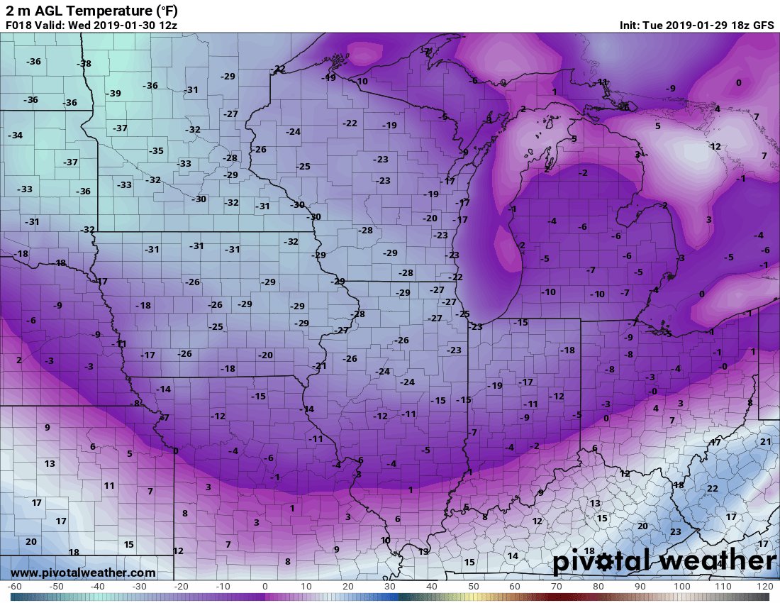
LIFE THREATENING COLD ARCTIC BLAST and POLAR VORTEX MOVES IN

*****DANGEROUS COLD WEATHER*****

*****LIFE THREATENING****

ACROSS THE NORTHERN PLAINS, THE CORNBELT, MIDWEST, GREAT LAKES, and EVENTUALLY MID ATLANTIC AND NORTHEASTERN UNITED STATES A MAJOR SEVERE LIFE THREATENING COLD OUTBREAK IS UPON US:

THIS HAS CLIMATE CHANGE ALL OVER IT AND SOMETHING MAY NEED TO BE DONE BEFORE AN ICE AGE BREAKS OUT:


...developing...